
Tormenta pasada
Ciclón postropical Boris
Boris alcanzó fuerza de tormenta tropical con vientos máximos sostenidos de 40 kt. El aviso final del NHC informó que Boris se había debilitado hasta convertirse en una baja remanente sobre el sur de México con 25 kt el 9 de junio de 2026, mientras continuaban las preocupaciones por lluvias intensas e inundaciones.
Clasificación máxima alcanzada: Tormenta tropicaljun 7–9, 2026
Aviso de Boris actualizado:
Datos clave
- Tipo
- Ciclón postropical
- Viento máximo
- 46 km/h
- Presión mínima
- 1004 mb
- Movimiento
- NW 11 km/h
- Centro a BCS
- 1307 km
- Centro al continente
- 0 km
- Tipo
- Ciclón postropical
- Viento máximo
- 46 km/h
- Presión mínima
- 1004 mb
- Movimiento
- NW 11 km/h
- Centro a BCS
- 1307 km
- Centro al continente
- 0 km
La distancia en la trayectoria entre posiciones reportadas es estimada. La distancia al centro no indica hasta dónde pueden llegar sus vientos y lluvias.
Trayectoria histórica
Tormenta histórica: Boris ocurrió antes del lanzamiento de BajaStorms. La línea muestra su trayectoria observada oficial final del NHC; no se capturó un pronóstico interactivo completo.
Fuentes del mapa: trayectoria y cono del NHC. Visualización de BajaStorms.
Gráficos oficiales
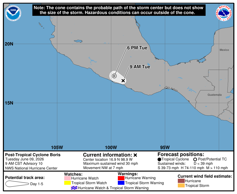
Cronología de avisos
Aviso #10
Boris se debilita hasta convertirse en una baja remanente sobre el sur de México. Se pronostica que la amenaza de inundaciones repentinas continúe durante el día.
Texto oficial del aviso del NHC
ZCZC MIATCPEP2 ALL
TTAA00 KNHC DDHHMM

BULLETIN
Post-Tropical Cyclone Boris Advisory Number  10
NWS National Hurricane Center Miami FL       EP022026
900 AM CST Tue Jun 09 2026

...BORIS DECAYS TO A REMNANT LOW OVER SOUTHERN MEXICO...
...FLASH FLOODING THREAT FORECAST TO CONTINUE THROUGH TODAY...


SUMMARY OF 900 AM CST...1500 UTC...INFORMATION
----------------------------------------------
LOCATION...16.9N 98.9W
ABOUT 65 MI...105 KM E OF ACAPULCO MEXICO
ABOUT 45 MI...75 KM NNW OF PUNTA MALDONADO MEXICO
MAXIMUM SUSTAINED WINDS...30 MPH...45 KM/H
PRESENT MOVEMENT...NW OR 305 DEGREES AT 7 MPH...11 KM/H
MINIMUM CENTRAL PRESSURE...1004 MB...29.65 INCHES


WATCHES AND WARNINGS
--------------------
There are no coastal watches or warnings in effect.


DISCUSSION AND OUTLOOK
----------------------
At 900 AM CST (1500 UTC), the center of Post-Tropical Cyclone Boris
was located near latitude 16.9 North, longitude 98.9 West. The
post-tropical cyclone is moving toward the northwest near 7 mph (11
km/h), and a west-northwestward motion is expected to continue
today.

Maximum sustained winds are now near 30 mph (45 km/h) with higher
gusts.  Boris is forecast to dissipate over the mountains of
southern Mexico later today or tonight.

The estimated minimum central pressure is 1004 mb (29.65 inches).


HAZARDS AFFECTING LAND
----------------------
Key messages for Boris can be found in the Tropical Cyclone
Discussion under AWIPS header MIATCDEP2 and WMO header WTPZ42 KNHC.

RAINFALL: The remnants of Boris are expected to produce additional
rainfall totals of 1 to 4 inches across coastal portions of the
Mexican states of Guerrero and Oaxaca today. Some risk of additional
flooding and mudslides continues this morning, especially in areas
of steep terrain.

For a complete depiction of forecast rainfall associated with
Tropical Storm Boris, please see the National Weather Service Storm
Total Rainfall Graphic available at
hurricanes.gov/graphics_ep2.shtml?rainqpf

WIND: Wind gusts to tropical-storm force will continue along
portions of the coast of southern Mexico for a few more hours.


NEXT ADVISORY
-------------
This is the last public advisory issued by the National Hurricane
Center on this system. For information regarding the ongoing threat
of heavy rainfall, please see forecasts and warnings from the
Meteorological Service of Mexico.

$$
Forecaster Beven

NNNN
Fuente: NOAA / NHC
Aviso #9
Boris avanza tierra adentro sobre el sur de México. Se pronostica que la amenaza de inundaciones repentinas continúe durante el día.
Texto oficial del aviso del NHC
ZCZC MIATCPEP2 ALL
TTAA00 KNHC DDHHMM

BULLETIN
Tropical Storm Boris Advisory Number   9
NWS National Hurricane Center Miami FL       EP022026
300 AM CST Tue Jun 09 2026

...BORIS MOVES INLAND OVER SOUTHERN MEXICO...
...FLASH FLOODING THREAT FORECAST TO CONTINUE THROUGH TODAY...


SUMMARY OF 300 AM CST...0900 UTC...INFORMATION
----------------------------------------------
LOCATION...16.4N 98.4W
ABOUT 105 MI...170 KM ESE OF ACAPULCO MEXICO
ABOUT 15 MI...25 KM ENE OF PUNTA MALDONADO MEXICO
MAXIMUM SUSTAINED WINDS...40 MPH...65 KM/H
PRESENT MOVEMENT...NNW OR 340 DEGREES AT 6 MPH...9 KM/H
MINIMUM CENTRAL PRESSURE...1003 MB...29.62 INCHES


WATCHES AND WARNINGS
--------------------
CHANGES WITH THIS ADVISORY:

None.

SUMMARY OF WATCHES AND WARNINGS IN EFFECT:

A Tropical Storm Warning is in effect for...
* Laguna de Chacahua to Tecpan de Galeana

A Tropical Storm Warning means that tropical storm conditions are
expected somewhere within the warning area.

For storm information specific to your area, please monitor
products issued by your national meteorological service.


DISCUSSION AND OUTLOOK
----------------------
At 300 AM CST (0900 UTC), the center of Tropical Storm Boris was
located near latitude 16.4 North, longitude 98.4 West. Boris is
moving toward the north-northwest near 6 mph (9 km/h). A turn toward
the northwest and an increase in forward speed is expected early
this morning. On the forecast track, the center of Boris will move
farther inland over eastern Guerrero this morning.

Maximum sustained winds are near 40 mph (65 km/h) with higher gusts.
Rapid weakening is expected, and Boris is forecast to dissipate
this afternoon.

Tropical-storm-force winds extend outward up to 60 miles (95 km)
from the center.

The estimated minimum central pressure is 1003 mb (29.62 inches).


HAZARDS AFFECTING LAND
----------------------
Key messages for Boris can be found in the Tropical Cyclone
Discussion under AWIPS header MIATCDEP2 and WMO header WTPZ42 KNHC.

RAINFALL: Boris is expected to produce additional rainfall totals of
1 to 4 inches across coastal portions of the Mexican states of
Guerrero and Oaxaca today. Some risk of additional flooding and
mudslides continues this morning, especially in areas of steep
terrain.

For a complete depiction of forecast rainfall associated with
Tropical Storm Boris, please see the National Weather Service Storm
Total Rainfall Graphic available at
hurricanes.gov/graphics_ep2.shtml?rainqpf

WIND: Tropical storm conditions are likely occurring along the
coast in the warning area and will continue through early this
morning.


NEXT ADVISORY
-------------
Next intermediate advisory at 600 AM CST.
Next complete advisory at 900 AM CST.

$$
Forecaster Hagen

NNNN
Fuente: NOAA / NHC
Aviso #8
Boris se acerca a la costa sur de México. Es probable que produzca inundaciones repentinas potencialmente mortales hasta el martes.
Texto oficial del aviso del NHC
ZCZC MIATCPEP2 ALL
TTAA00 KNHC DDHHMM

BULLETIN
Tropical Storm Boris Advisory Number   8
NWS National Hurricane Center Miami FL       EP022026
900 PM CST Mon Jun 08 2026

...BORIS CLOSING IN ON THE SOUTHERN MEXICAN COASTLINE...
...LIKELY TO PRODUCE LIFE-THREATENING FLASH FLOODING THROUGH
TUESDAY...


SUMMARY OF 900 PM CST...0300 UTC...INFORMATION
----------------------------------------------
LOCATION...16.0N 98.3W
ABOUT 125 MI...200 KM ESE OF ACAPULCO MEXICO
ABOUT 30 MI...45 KM SE OF PUNTA MALDONADO MEXICO
MAXIMUM SUSTAINED WINDS...45 MPH...75 KM/H
PRESENT MOVEMENT...N OR 360 DEGREES AT 2 MPH...4 KM/H
MINIMUM CENTRAL PRESSURE...1001 MB...29.56 INCHES


WATCHES AND WARNINGS
--------------------
CHANGES WITH THIS ADVISORY:

None.

SUMMARY OF WATCHES AND WARNINGS IN EFFECT:

A Tropical Storm Warning is in effect for...
* Laguna de Chacahua to Tecpan de Galeana

A Tropical Storm Warning means that tropical storm conditions are
expected somewhere within the warning area, in this case over the
next 12 hours.

For storm information specific to your area, please monitor
products issued by your national meteorological service.


DISCUSSION AND OUTLOOK
----------------------
At 900 PM CST (0300 UTC), the center of Tropical Storm Boris was
located near latitude 16.0 North, longitude 98.3 West. Boris is
moving toward the north near 2 mph (4 km/h), and a turn toward the
northwest and an increase in forward speed is expected overnight. On
the forecast track, the center of Boris should reach the coast of
Oaxaca and Guerrero, Mexico, late tonight into Tuesday morning.

Maximum sustained winds are near 45 mph (75 km/h) with higher gusts.
Little change in strength is forecast until landfall. Rapid
weakening will occur after the center crosses the coast of southern
Mexico.

Tropical-storm-force winds extend outward up to 60 miles (95 km)
from the center.

The estimated minimum central pressure is 1001 mb (29.56 inches).


HAZARDS AFFECTING LAND
----------------------
Key messages for Boris can be found in the Tropical Cyclone
Discussion under AWIPS header MIATCDEP2 and WMO header WTPZ42 KNHC.

RAINFALL: Boris is expected to produce additional rainfall totals of
3 to 6 inches, with maximum totals of 8 inches possible across
coastal portions of the Mexican states of Guerrero and Oaxaca
through Tuesday. This rainfall may produce life-threatening flooding
and mudslides, especially in areas of steep terrain.

For a complete depiction of forecast rainfall associated with
Tropical Storm Boris, please see the National Weather Service Storm
Total Rainfall Graphic available at
hurricanes.gov/graphics_ep2.shtml?rainqpf

WIND:  Tropical storm conditions are likely occurring along the
coast in the warning area and will continue into early Tuesday.


NEXT ADVISORY
-------------
Next intermediate advisory at 1200 AM CST.
Next complete advisory at 300 AM CST.

$$
Forecaster Adams/Papin

NNNN
Fuente: NOAA / NHC
Aviso #7
Boris lleva lluvias que causan inundaciones a partes del sur de México.
Texto oficial del aviso del NHC
ZCZC MIATCPEP2 ALL
TTAA00 KNHC DDHHMM

BULLETIN
Tropical Storm Boris Advisory Number   7
NWS National Hurricane Center Miami FL       EP022026
300 PM CST Mon Jun 08 2026

...BORIS BRINGING FLOODING RAINS TO PORTIONS OF SOUTHERN MEXICO...


SUMMARY OF 300 PM CST...2100 UTC...INFORMATION
----------------------------------------------
LOCATION...15.5N 99.0W
ABOUT 115 MI...185 KM SSE OF ACAPULCO MEXICO
ABOUT 60 MI...100 KM SSW OF PUNTA MALDONADO MEXICO
MAXIMUM SUSTAINED WINDS...45 MPH...75 KM/H
PRESENT MOVEMENT...NE OR 50 DEGREES AT 3 MPH...6 KM/H
MINIMUM CENTRAL PRESSURE...1001 MB...29.56 INCHES


WATCHES AND WARNINGS
--------------------
CHANGES WITH THIS ADVISORY:

None.

SUMMARY OF WATCHES AND WARNINGS IN EFFECT:

A Tropical Storm Warning is in effect for...
* Laguna de Chacahua to Tecpan de Galeana

A Tropical Storm Warning means that tropical storm conditions are
expected somewhere within the warning area, in this case within 12
to 24 hours.

For storm information specific to your area, please monitor
products issued by your national meteorological service.


DISCUSSION AND OUTLOOK
----------------------
At 300 PM CST (2100 UTC), the center of Tropical Storm Boris was
located near latitude 15.5 North, longitude 99.0 West.  Boris is
moving toward the northeast near 3 mph (6 km/h) and a turn toward
the north is expected later today followed by a turn to the
northwest on Tuesday.  On the forecast track, the center of Boris
should reach the coast of Guerrero, Mexico, by early Tuesday.

Maximum sustained winds are near 45 mph (75 km/h) with higher gusts.
Little change in strength is forecast until landfall.  Rapid
weakening will occur after the center crosses the coast of southern
Mexico.

Tropical-storm-force winds extend outward up to 60 miles (95 km)
from the center.

The estimated minimum central pressure is 1001 mb (29.56 inches).


HAZARDS AFFECTING LAND
----------------------
Key messages for Boris can be found in the Tropical Cyclone
Discussion under AWIPS header MIATCDEP2 and WMO header WTPZ42 KNHC.

RAINFALL: Boris is expected to produce additional rainfall totals of
3 to 6 inches, with maximum totals of 8 inches possible across
coastal portions of the Mexican states of Guerrero and Oaxaca
through Tuesday.  This rainfall may produce life-threatening
flooding and mudslides, especially in areas of steep terrain.

For a complete depiction of forecast rainfall associated with
Boris, please see the National Weather Service Storm Total Rainfall
Graphic available at hurricanes.gov/graphics_ep2.shtml?rainqpf

WIND:  Tropical storm conditions are expected to begin along the
coast within the warning area tonight or early Tuesday.


NEXT ADVISORY
-------------
Next intermediate advisory at 600 PM CST.
Next complete advisory at 900 PM CST.

$$
Forecaster Pasch

NNNN
Fuente: NOAA / NHC
Aviso #6
El centro de Boris está más al sur de lo estimado anteriormente. Ahora se espera que toque tierra el martes.
Texto oficial del aviso del NHC
ZCZC MIATCPEP2 ALL
TTAA00 KNHC DDHHMM

BULLETIN
Tropical Storm Boris Special Advisory Number   6
NWS National Hurricane Center Miami FL       EP022026
1200 PM CST Mon Jun 08 2026

...CENTER OF BORIS IS FARTHER SOUTH THAN PREVIOUSLY ESTIMATED...
...NOW EXPECTED TO MAKE LANDFALL ON TUESDAY...


SUMMARY OF 1200 PM CST...1800 UTC...INFORMATION
-----------------------------------------------
LOCATION...15.3N 99.2W
ABOUT 120 MI...195 KM SSE OF ACAPULCO MEXICO
ABOUT 80 MI...130 KM SSW OF PUNTA MALDONADO MEXICO
MAXIMUM SUSTAINED WINDS...45 MPH...75 KM/H
PRESENT MOVEMENT...ENE OR 60 DEGREES AT 3 MPH...6 KM/H
MINIMUM CENTRAL PRESSURE...1001 MB...29.56 INCHES


WATCHES AND WARNINGS
--------------------
CHANGES WITH THIS ADVISORY:

None.

SUMMARY OF WATCHES AND WARNINGS IN EFFECT:

A Tropical Storm Warning is in effect for...
* Laguna de Chacahua to Tecpan de Galeana

A Tropical Storm Warning means that tropical storm conditions are
expected somewhere within the warning area, in this case within 12
to 24 hours.

For storm information specific to your area, please monitor
products issued by your national meteorological service.


DISCUSSION AND OUTLOOK
----------------------
At 1200 PM CST (1800 UTC), the center of Tropical Storm Boris was
located near latitude 15.3 North, longitude 99.2 West.  Boris is
moving toward the east-northeast near 3 mph (6 km/h) and a turn
toward the north is expected later today followed by a turn to
the northwest on Tuesday.  On the forecast track, the center of
Boris should reach the coast of Guerrero, Mexico, on Tuesday.

Maximum sustained winds are near 45 mph (75 km/h) with higher gusts.
Little change in strength is forecast until landfall.  Rapid
weakening will occur after the center crosses the coast of southern
Mexico.

Tropical-storm-force winds extend outward up to 35 miles (55 km)
from the center.

The estimated minimum central pressure is 1001 mb (29.56 inches).


HAZARDS AFFECTING LAND
----------------------
Key messages for Boris can be found in the Tropical Cyclone
Discussion under AWIPS header MIATCDEP2 and WMO header WTPZ42 KNHC.

RAINFALL: Boris is expected to produce additional rainfall totals of
4 to 8 inches, with maximum totals of 12 inches possible across
coastal portions of the Mexican states of Guerrero and Oaxaca
through Tuesday. This rainfall may produce life-threatening flooding
and mudslides, especially in areas of steep terrain.

For a complete depiction of forecast rainfall associated with
Boris, please see the National Weather Service Storm Total Rainfall
Graphic available at hurricanes.gov/graphics_ep2.shtml?rainqpf

WIND:  Tropical storm conditions are expected to begin along the
coast within the warning area tonight or early Tuesday.


NEXT ADVISORY
-------------
Next intermediate advisory at 1200 PM CST.
Next complete advisory at 300 PM CST.

$$
Forecaster Pasch

NNNN
Fuente: NOAA / NHC