
Tormenta pasada
Baja remanente Cristina
Cristina alcanzó fuerza de tormenta tropical con vientos máximos sostenidos de 40 kt. El aviso final del NHC informó que Cristina se había convertido en una débil vaguada de baja presión cerca de la costa de El Salvador con vientos de 20 kt el 11 de junio de 2026.
Clasificación máxima alcanzada: Tormenta tropicaljun 8–11, 2026
Aviso de Cristina actualizado:
Datos clave
- Tipo
- Baja remanente
- Viento máximo
- 37 km/h
- Presión mínima
- 1007 mb
- Movimiento
- NW 11 km/h
- Centro a BCS
- 2417 km
- Centro al continente
- 351 km
- Tipo
- Baja remanente
- Viento máximo
- 37 km/h
- Presión mínima
- 1007 mb
- Movimiento
- NW 11 km/h
- Centro a BCS
- 2417 km
- Centro al continente
- 351 km
La distancia en la trayectoria entre posiciones reportadas es estimada. La distancia al centro no indica hasta dónde pueden llegar sus vientos y lluvias.
Trayectoria histórica
Tormenta histórica: Cristina ocurrió antes del lanzamiento de BajaStorms. La línea muestra su trayectoria observada oficial final del NHC; no se capturó un pronóstico interactivo completo.
Fuentes del mapa: trayectoria y cono del NHC. Visualización de BajaStorms.
Gráficos oficiales
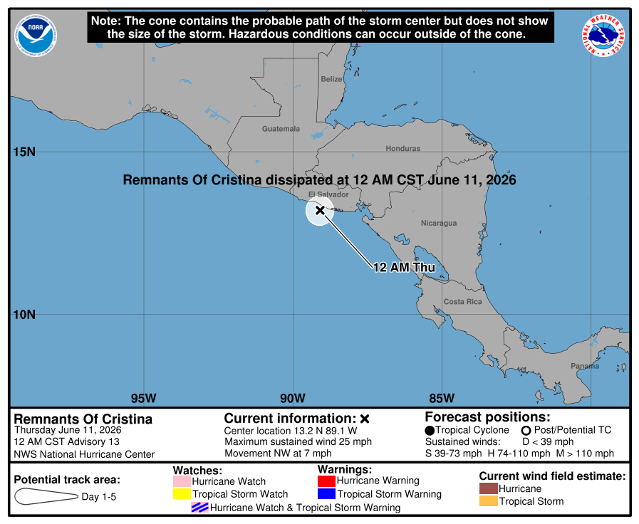
Cronología de avisos
Aviso #13
Cristina se degenera hasta convertirse en una débil vaguada de baja presión cerca de la costa de El Salvador. Este es el aviso final del NHC.
Texto oficial del aviso del NHC
ZCZC MIATCPEP3 ALL
TTAA00 KNHC DDHHMM

BULLETIN
Remnants Of Cristina Special Advisory Number  13
NWS National Hurricane Center Miami FL       EP032026
1200 AM CST Thu Jun 11 2026

...CRISTINA DEGENERATES TO A WEAK TROUGH OF LOW PRESSURE NEAR THE
COAST OF EL SALVADOR...
...THIS IS THE FINAL NHC ADVISORY...


SUMMARY OF 1200 AM CST...0600 UTC...INFORMATION
-----------------------------------------------
LOCATION...13.2N 89.1W
ABOUT 35 MI...55 KM S OF SAN SALVADOR EL SALVADOR
MAXIMUM SUSTAINED WINDS...25 MPH...35 KM/H
PRESENT MOVEMENT...NW OR 325 DEGREES AT 7 MPH...11 KM/H
MINIMUM CENTRAL PRESSURE...1007 MB...29.74 INCHES


WATCHES AND WARNINGS
--------------------
CHANGES WITH THIS ADVISORY:

The government of El Salvador has discontinued the Tropical Storm
Watch.

SUMMARY OF WATCHES AND WARNINGS IN EFFECT:

There are no coastal watches or warnings in effect.


DISCUSSION AND OUTLOOK
----------------------
At 1200 AM CST (0600 UTC), the remnants of Cristina were located
near latitude 13.2 North, longitude 89.1 West. The remnants are
moving toward the northwest near 7 mph (11 km/h), and this general
motion is expected to continue today.

Maximum sustained winds have decreased to near 25 mph (35 km/h) with
higher gusts.

The estimated minimum central pressure is 1007 mb (29.74 inches).


HAZARDS AFFECTING LAND
----------------------
Key messages for the remnants of Cristina can be found in the
Tropical Cyclone Discussion under AWIPS header MIATCDEP3 and WMO
header WTPZ43 KNHC.

RAINFALL: The remnants of Cristina are expected to produce rainfall
totals of 4 to 8 inches, with maximum totals of 12 inches possible
across portions of El Salvador through tonight. This rainfall may
produce life-threatening flooding and mudslides, especially in areas
of steep terrain.

For a complete depiction of forecast rainfall, please see the
National Weather Service Storm Total Rainfall Graphic available at
hurricanes.gov/graphics_ep3.shtml?rainqpf


NEXT ADVISORY
-------------
This is the last public advisory issued by the National Hurricane
Center on this system. For additional information please see High
Seas Forecasts issued by the National Weather Service, under AWIPS
header NFDHSFEPI, WMO header FZPN02 KWBC, and on the web at
ocean.weather.gov/shtml/NFDHSFEPI.php


$$
Forecaster Reinhart

NNNN
Fuente: NOAA / NHC
Aviso #12
Cristina está poco organizada cerca de la costa de El Salvador. Se espera que las lluvias intensas continúen en partes de Centroamérica hasta el jueves.
Texto oficial del aviso del NHC
ZCZC MIATCPEP3 ALL
TTAA00 KNHC DDHHMM

BULLETIN
Tropical Depression Cristina Advisory Number  12
NWS National Hurricane Center Miami FL       EP032026
900 PM CST Wed Jun 10 2026

...POORLY ORGANIZED CRISTINA CLOSE TO THE COAST OF EL SALVADOR...
...HEAVY RAINS EXPECTED TO CONTINUE OVER PORTIONS OF CENTRAL AMERICA
THROUGH THURSDAY...


SUMMARY OF 900 PM CST...0300 UTC...INFORMATION
----------------------------------------------
LOCATION...13.1N 89.3W
ABOUT 40 MI...70 KM S OF SAN SALVADOR EL SALVADOR
ABOUT 115 MI...185 KM ESE OF PUERTO SAN JOSE GUATEMALA
MAXIMUM SUSTAINED WINDS...35 MPH...55 KM/H
PRESENT MOVEMENT...NW OR 315 DEGREES AT 5 MPH...7 KM/H
MINIMUM CENTRAL PRESSURE...1007 MB...29.74 INCHES


WATCHES AND WARNINGS
--------------------
CHANGES WITH THIS ADVISORY:

None.

SUMMARY OF WATCHES AND WARNINGS IN EFFECT:

A Tropical Storm Watch is in effect for...
* The Pacific coast of El Salvador from the El Salvador/Honduras
border to the Guatemala/El Salvador border

A Tropical Storm Watch means that tropical storm conditions are
possible within the watch area.

Interests along the Pacific coast of Guatemala should monitor the
progress of Cristina.

For storm information specific to your area, please monitor
products issued by your national meteorological service.


DISCUSSION AND OUTLOOK
----------------------
At 900 PM CST (0300 UTC), the center of Tropical Depression Cristina
was located near latitude 13.1 North, longitude 89.3 West. The
depression is moving toward the northwest near 5 mph (7 km/h) and
this motion is expected to continue through Thursday.  On the
forecast track, the center of Cristina should make landfall in El
Salvador tonight, then move inland over El Salvador and into
southern Guatemala by Thursday.

Maximum sustained winds are near 35 mph (55 km/h) with higher gusts.
Little change in strength is forecast before the center moves
inland. After landfall, Cristina is expected to dissipate over
Guatemala on Thursday.

The estimated minimum central pressure is 1007 mb (29.74 inches).


HAZARDS AFFECTING LAND
----------------------
Key messages for Cristina can be found in the Tropical Cyclone
Discussion under AWIPS header MIATCDEP3 and WMO header WTPZ43 KNHC.

RAINFALL: Tropical Depression Cristina is expected to produce
rainfall totals of 4 to 8 inches, with maximum totals of 12 inches
possible across portions of El Salvador through Thursday night. This
rainfall may produce life-threatening flooding and mudslides,
especially in areas of steep terrain.

For a complete depiction of forecast rainfall associated with
Tropical Depression Cristina, please see the National Weather
Service Storm Total Rainfall Graphic available at
hurricanes.gov/graphics_ep3.shtml?rainqpf

STORM SURGE: Minor coastal flooding is possible in areas of onshore
winds and could be accompanied by large waves.

WIND: Tropical storm conditions are possible in the watch area
tonight.


NEXT ADVISORY
-------------
Next intermediate advisory at 1200 AM CST.
Next complete advisory at 300 AM CST.

$$
Forecaster Papin

NNNN
Fuente: NOAA / NHC
Aviso #11
Cristina ahora se mueve hacia el noroeste rumbo a la costa de El Salvador. Se espera que las lluvias intensas continúen en partes de Centroamérica hasta el jueves.
Texto oficial del aviso del NHC
ZCZC MIATCPEP3 ALL
TTAA00 KNHC DDHHMM

BULLETIN
Tropical Depression Cristina Advisory Number  11
NWS National Hurricane Center Miami FL       EP032026
300 PM CST Wed Jun 10 2026

...CRISTINA NOW MOVING NORTHWESTWARD TOWARD THE COAST OF EL
SALVADOR...
...HEAVY RAINS EXPECTED TO CONTINUE OVER PORTIONS OF CENTRAL AMERICA
THROUGH THURSDAY...


SUMMARY OF 300 PM CST...2100 UTC...INFORMATION
----------------------------------------------
LOCATION...12.6N 88.9W
ABOUT 80 MI...125 KM SSE OF SAN SALVADOR EL SALVADOR
ABOUT 155 MI...250 KM SE OF PUERTO SAN JOSE GUATEMALA
MAXIMUM SUSTAINED WINDS...35 MPH...55 KM/H
PRESENT MOVEMENT...NW OR 305 DEGREES AT 5 MPH...7 KM/H
MINIMUM CENTRAL PRESSURE...1007 MB...29.74 INCHES


WATCHES AND WARNINGS
--------------------
CHANGES WITH THIS ADVISORY:

The Government of Honduras has discontinued the Tropical Storm
Warning for the Pacific coast of Honduras.

The Government of El Salvador has changed the Tropical Storm
Warning to a Tropical Storm Watch for the Pacific coast of El
Salvador.

SUMMARY OF WATCHES AND WARNINGS IN EFFECT:

A Tropical Storm Watch is in effect for...
* The Pacific coast of El Salvador from the El Salvador/Honduras
border to the Guatemala/El Salvador border

A Tropical Storm Watch means that tropical storm conditions are
possible within the watch area.

Interests along the Pacific coast of Guatemala should monitor the
progress of Cristina.

For storm information specific to your area, please monitor
products issued by your national meteorological service.


DISCUSSION AND OUTLOOK
----------------------
At 300 PM CST (2100 UTC), the center of Tropical Depression Cristina
was located near latitude 12.6 North, longitude 88.9 West. The
depression is moving toward the northwest near 5 mph (7 km/h), and
this motion is expected to continue through Thursday.  On the
forecast track, the center of Cristina should approach the coast of
El Salvador this evening, then move inland over El Salvador tonight
and into southern Guatemala by Thursday.

Maximum sustained winds are near 35 mph (55 km/h) with higher gusts.
Little change in strength is forecast before the center moves
inland. After landfall, Cristina is expected to dissipate over
Guatemala on Thursday.

The estimated minimum central pressure is 1007 mb (29.74 inches).


HAZARDS AFFECTING LAND
----------------------
Key messages for Cristina can be found in the Tropical Cyclone
Discussion under AWIPS header MIATCDEP3 and WMO header WTPZ43 KNHC.

RAINFALL: Tropical Depression Cristina is expected to produce
rainfall totals of 4 to 8 inches, with maximum totals of 12 inches
possible across coastal portions of Nicaragua, Honduras, El
Salvador, and Guatemala through Thursday night. This rainfall may
produce life-threatening flooding and mudslides, especially in areas
of steep terrain.

For a complete depiction of forecast rainfall associated with
Tropical Depression Cristina, please see the National Weather
Service Storm Total Rainfall Graphic available at
hurricanes.gov/graphics_ep3.shtml?rainqpf

STORM SURGE: Minor coastal flooding is possible in areas of onshore
winds and could be accompanied by large waves.

WIND: Tropical storm conditions are possible in the watch area
later today and tonight.


NEXT ADVISORY
-------------
Next intermediate advisory at 600 PM CST.
Next complete advisory at 900 PM CST.

$$
Forecaster Beven

NNNN
Fuente: NOAA / NHC
Aviso #10
Se espera que Cristina gire hacia el noroeste durante las próximas horas. Se espera que las lluvias intensas continúen en partes de Centroamérica hasta el jueves.
Texto oficial del aviso del NHC
ZCZC MIATCPEP3 ALL
TTAA00 KNHC DDHHMM

BULLETIN
Tropical Storm Cristina Advisory Number  10
NWS National Hurricane Center Miami FL       EP032026
900 AM CST Wed Jun 10 2026

...CRISTINA EXPECTED TO TURN NORTHWESTWARD DURING THE NEXT
SEVERAL HOURS...
...HEAVY RAINS EXPECTED TO CONTINUE OVER PORTIONS OF CENTRAL AMERICA
THROUGH THURSDAY...


SUMMARY OF 900 AM CST...1500 UTC...INFORMATION
----------------------------------------------
LOCATION...12.5N 88.8W
ABOUT 85 MI...140 KM SSE OF SAN SALVADOR EL SALVADOR
ABOUT 165 MI...265 KM SE OF PUERTO SAN JOSE GUATEMALA
MAXIMUM SUSTAINED WINDS...40 MPH...65 KM/H
PRESENT MOVEMENT...W OR 270 DEGREES AT 3 MPH...6 KM/H
MINIMUM CENTRAL PRESSURE...1006 MB...29.71 INCHES


WATCHES AND WARNINGS
--------------------
CHANGES WITH THIS ADVISORY:

The government of Nicaragua has discontinued the Tropical Storm
Warning for the Pacific coast of Nicaragua.

SUMMARY OF WATCHES AND WARNINGS IN EFFECT:

A Tropical Storm Warning is in effect for...
* The Pacific coast from the Honduras/Nicaragua border to
the Guatemala/El Salvador border

A Tropical Storm Warning means that tropical storm conditions are
expected somewhere within the warning area.

Interests along the Pacific coast of Guatemala should monitor the
progress of Cristina.

For storm information specific to your area, please monitor
products issued by your national meteorological service.


DISCUSSION AND OUTLOOK
----------------------
At 900 AM CST (1500 UTC), the center of Tropical Storm Cristina was
located near latitude 12.5 North, longitude 88.8 West. Cristina is
moving toward the west near 3 mph (6 km/h). A turn toward the
northwest is expected later today, with a continued northwestward
motion tonight and on Thursday. On the forecast track, Cristina
should linger offshore of El Salvador, Honduras, and Nicaragua
today and then move near or over the coast of El Salvador tonight
into Thursday.

Maximum sustained winds are near 40 mph (65 km/h) with higher gusts.
Slight strengthening is possible through tonight, with weakening
forecast on Thursday after Cristina moves inland.

Tropical-storm-force winds extend outward up to 70 miles (110 km)
from the center.

The estimated minimum central pressure is 1006 mb (29.71 inches).


HAZARDS AFFECTING LAND
----------------------
Key messages for Cristina can be found in the Tropical Cyclone
Discussion under AWIPS header MIATCDEP3 and WMO header WTPZ43 KNHC.

RAINFALL: Tropical Storm Cristina is expected to produce rainfall
totals of 4 to 8 inches, with maximum totals of 12 inches possible
across coastal portions Nicaragua, Honduras, El Salvador, and
Guatemala through Thursday night. This rainfall may produce
life-threatening flooding and mudslides, especially in areas of
steep terrain.

For a complete depiction of forecast rainfall associated with
Tropical Storm Cristina, please see the National Weather Service
Storm Total Rainfall Graphic available at
hurricanes.gov/graphics_ep3.shtml?rainqpf

STORM SURGE: Coastal flooding from storm surge is possible in areas
of onshore winds. Near the coast, the surge will be accompanied by
large and damaging waves.

WIND: Tropical storm conditions are expected to spread along
portions of the coast within the warning area today and tonight.


NEXT ADVISORY
-------------
Next intermediate advisory at 1200 PM CST.
Next complete advisory at 300 PM CST.

$$
Forecaster Beven

NNNN
Fuente: NOAA / NHC
Aviso #9
Cristina deriva hacia el oeste mar adentro de El Salvador. Se espera que las lluvias intensas continúen en partes de Centroamérica hasta el jueves.
Texto oficial del aviso del NHC
ZCZC MIATCPEP3 ALL
TTAA00 KNHC DDHHMM

BULLETIN
Tropical Storm Cristina Advisory Number   9
NWS National Hurricane Center Miami FL       EP032026
300 AM CST Wed Jun 10 2026

...CRISTINA DRIFTING WESTWARD OFFSHORE OF EL SALVADOR...
...HEAVY RAINS EXPECTED TO CONTINUE OVER PORTIONS OF CENTRAL AMERICA
THROUGH THURSDAY...


SUMMARY OF 300 AM CST...0900 UTC...INFORMATION
----------------------------------------------
LOCATION...12.4N 88.5W
ABOUT 100 MI...165 KM SSE OF SAN SALVADOR EL SALVADOR
ABOUT 150 MI...240 KM W OF MANAGUA NICARAGUA
MAXIMUM SUSTAINED WINDS...40 MPH...65 KM/H
PRESENT MOVEMENT...W OR 260 DEGREES AT 3 MPH...6 KM/H
MINIMUM CENTRAL PRESSURE...1006 MB...29.71 INCHES


WATCHES AND WARNINGS
--------------------
CHANGES WITH THIS ADVISORY:

None.

SUMMARY OF WATCHES AND WARNINGS IN EFFECT:

A Tropical Storm Warning is in effect for...
* Puerto Sandino, Nicaragua to the Guatemala/El Salvador border

A Tropical Storm Warning means that tropical storm conditions are
expected somewhere within the warning area.

For storm information specific to your area, please monitor
products issued by your national meteorological service.


DISCUSSION AND OUTLOOK
----------------------
At 300 AM CST (0900 UTC), the center of Tropical Storm Cristina was
located near latitude 12.4 North, longitude 88.5 West. Cristina is
moving toward the west near 3 mph (6 km/h). A turn toward the
west-northwest and northwest is expected today and tonight, with a
continued northwestward motion on Thursday. On the forecast track,
Cristina should linger offshore of El Salvador, Honduras, and
Nicaragua today and then approach the coast of El Salvador tonight
into early Thursday.

Maximum sustained winds are near 40 mph (65 km/h) with higher gusts.
Slight strengthening is possible through tonight, with weakening
forecast on Thursday after Cristina moves inland.

Tropical-storm-force winds extend outward up to 70 miles (110 km)
mainly to the south of the center.

The estimated minimum central pressure is 1006 mb (29.71 inches).


HAZARDS AFFECTING LAND
----------------------
Key messages for Cristina can be found in the Tropical Cyclone
Discussion under AWIPS header MIATCDEP3 and WMO header WTPZ43 KNHC.

RAINFALL: Tropical Storm Cristina is expected to produce rainfall
totals of 4 to 8 inches, with maximum totals of 12 inches possible
across coastal portions of Nicaragua, Honduras, El Salvador, and
Guatemala through Thursday morning. This rainfall may produce
life-threatening flooding and mudslides, especially in areas of
steep terrain.

For a complete depiction of forecast rainfall associated with
Cristina, please see the National Weather Service Storm Total
Rainfall Graphic available at
hurricanes.gov/graphics_ep3.shtml?rainqpf

STORM SURGE: Coastal flooding from storm surge is possible in areas
of onshore winds. Near the coast, the surge will be accompanied by
large and damaging waves.

WIND: Tropical storm conditions are expected to spread along
portions of the coast within the warning area today and tonight.


NEXT ADVISORY
-------------
Next intermediate advisory at 600 AM CST.
Next complete advisory at 900 AM CST.

$$
Forecaster Reinhart

NNNN
Fuente: NOAA / NHC