
Past storm
Post-Tropical Cyclone Amanda
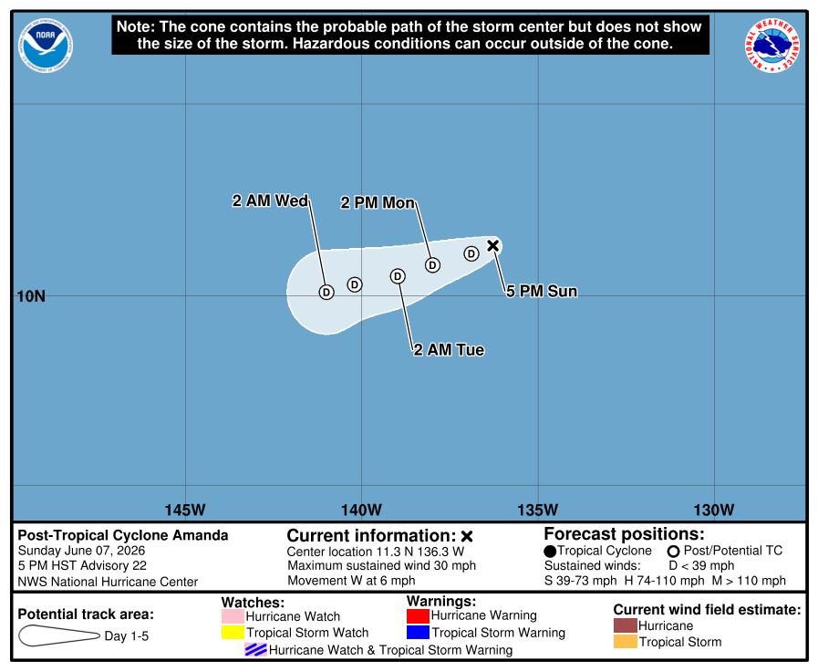
Amanda reached tropical-storm strength with peak sustained winds of 40 kt. The final NHC advisory reported that Amanda had become a post-tropical remnant low at 25 kt near 11.3°N, 136.3°W on June 8, 2026.
Highest classification reached: Tropical StormJun 2–8, 2026
Amanda advisory updated:
Key Facts
- Type
- Post-Tropical Cyclone
- Max sustained wind
- 29 mph
- Min pressure
- 1007 mb
- Movement
- W 6 mph
- Storm center to BCS
- 1787 mi
- Center to Mainland
- 1969 mi
- Type
- Post-Tropical Cyclone
- Max sustained wind
- 29 mph
- Min pressure
- 1007 mb
- Movement
- W 6 mph
- Storm center to BCS
- 1787 mi
- Center to Mainland
- 1969 mi
Track distance between reported center positions is estimated. Center distance does not show how far winds and rain can reach.
Historical Track
Historical storm: Amanda occurred before BajaStorms launched. The line shows its finalized official NHC observed track; a complete interactive forecast was not captured.
Map sources: NHC storm track and cone. Visualization by BajaStorms.
Official Graphics
Advisory Timeline
Advisory #22
Amanda degenerates to a post-tropical remnant low.
Official NHC advisory text
ZCZC MIATCPEP1 ALL
TTAA00 KNHC DDHHMM

BULLETIN
Post-Tropical Cyclone Amanda Advisory Number  22
NWS National Hurricane Center Miami FL       EP012026
500 PM HST Sun Jun 07 2026

...AMANDA DEGENERATES TO A POST-TROPICAL REMNANT LOW...


SUMMARY OF 500 PM HST...0300 UTC...INFORMATION
----------------------------------------------
LOCATION...11.3N 136.3W
ABOUT 1375 MI...2215 KM ESE OF HILO HAWAII
MAXIMUM SUSTAINED WINDS...30 MPH...45 KM/H
PRESENT MOVEMENT...W OR 260 DEGREES AT 6 MPH...9 KM/H
MINIMUM CENTRAL PRESSURE...1007 MB...29.74 INCHES


WATCHES AND WARNINGS
--------------------
There are no coastal watches or warnings in effect.


DISCUSSION AND OUTLOOK
----------------------
At 500 PM HST (0300 UTC), the center of Post-Tropical Cyclone Amanda
was located near latitude 11.3 North, longitude 136.3 West. The
post-tropical cyclone is moving toward the west near 6 mph (9 km/h)
and this motion is generally expected to continue over the next
several days.

Maximum sustained winds have decreased to near 30 mph (45 km/h) with
higher gusts. The post-tropical remnant low of Amanda is forecast to
dissipate by mid-week.

The estimated minimum central pressure is 1007 mb (29.74 inches).


HAZARDS AFFECTING LAND
----------------------
None.


NEXT ADVISORY
-------------
This is the last public advisory issued by the National Hurricane
Center on this system. For additional information on the remnant low
please see High Seas Forecasts issued by the National Weather
Service, under AWIPS header NFDHSFEPI, WMO header FZPN02 KWBC, and
on the web at ocean.weather.gov/shtml/NFDHSFEPI.php


$$
Forecaster Adams/Papin

NNNN
Source: NOAA / NHC
Advisory #21
Amanda is forecast to become a post-tropical remnant low later tonight.
Official NHC advisory text
ZCZC MIATCPEP1 ALL
TTAA00 KNHC DDHHMM

BULLETIN
Tropical Depression Amanda Advisory Number  21
NWS National Hurricane Center Miami FL       EP012026
1100 AM HST Sun Jun 07 2026

...AMANDA FORECAST TO BECOME A POST-TROPICAL REMNANT LOW LATER
TONIGHT...


SUMMARY OF 1100 AM HST...2100 UTC...INFORMATION
-----------------------------------------------
LOCATION...11.3N 135.7W
ABOUT 1415 MI...2275 KM ESE OF HILO HAWAII
MAXIMUM SUSTAINED WINDS...35 MPH...55 KM/H
PRESENT MOVEMENT...WSW OR 245 DEGREES AT 5 MPH...7 KM/H
MINIMUM CENTRAL PRESSURE...1007 MB...29.74 INCHES


WATCHES AND WARNINGS
--------------------
There are no coastal watches or warnings in effect.


DISCUSSION AND OUTLOOK
----------------------
At 1100 AM HST (2100 UTC), the center of Tropical Depression Amanda
was located near latitude 11.3 North, longitude 135.7 West. The
depression is moving toward the west-southwest near 5 mph (7 km/h)
and this general motion is expected to continue through mid-week.

Maximum sustained winds are near 35 mph (55 km/h) with higher gusts.
Amanda is expected to become a post-tropical remnant low by tonight
and dissipation in a few days.

The estimated minimum central pressure is 1007 mb (29.74 inches).


HAZARDS AFFECTING LAND
----------------------
None.


NEXT ADVISORY
-------------
Next complete advisory at 500 PM HST.

$$
Forecaster Roberts

NNNN
Source: NOAA / NHC
Advisory #20
Amanda is forecast to become a post-tropical remnant low soon.
Official NHC advisory text
ZCZC MIATCPEP1 ALL
TTAA00 KNHC DDHHMM

BULLETIN
Tropical Depression Amanda Advisory Number  20
NWS National Hurricane Center Miami FL       EP012026
500 AM HST Sun Jun 07 2026

...AMANDA FORECAST TO BECOME A POST-TROPICAL REMNANT LOW SOON...


SUMMARY OF 500 AM HST...1500 UTC...INFORMATION
----------------------------------------------
LOCATION...11.5N 135.4W
ABOUT 1425 MI...2295 KM ESE OF HILO HAWAII
MAXIMUM SUSTAINED WINDS...35 MPH...55 KM/H
PRESENT MOVEMENT...SW OR 235 DEGREES AT 5 MPH...7 KM/H
MINIMUM CENTRAL PRESSURE...1007 MB...29.74 INCHES


WATCHES AND WARNINGS
--------------------
There are no coastal watches or warnings in effect.


DISCUSSION AND OUTLOOK
----------------------
At 500 AM HST (1500 UTC), the center of Tropical Depression Amanda
was located near latitude 11.5 North, longitude 135.4 West. The
depression is moving toward the southwest near 5 mph (7 km/h) and
turn toward the west-southwest is expected today.

Maximum sustained winds are near 35 mph (55 km/h) with higher gusts.
Amanda is expected to become a post-tropical remnant low by tonight.

The estimated minimum central pressure is 1007 mb (29.74 inches).


HAZARDS AFFECTING LAND
----------------------
None.


NEXT ADVISORY
-------------
Next complete advisory at 1100 AM HST.

$$
Forecaster Roberts

NNNN
Source: NOAA / NHC
Advisory #19
Amanda is forecast to become a remnant low by late sunday.
Official NHC advisory text
ZCZC MIATCPEP1 ALL
TTAA00 KNHC DDHHMM

BULLETIN
Tropical Depression Amanda Advisory Number  19
NWS National Hurricane Center Miami FL       EP012026
1100 PM HST Sat Jun 06 2026

...AMANDA FORECAST TO BECOME A REMNANT LOW BY LATE SUNDAY...


SUMMARY OF 1100 PM HST...0900 UTC...INFORMATION
-----------------------------------------------
LOCATION...11.7N 135.1W
ABOUT 1440 MI...2315 KM ESE OF HILO HAWAII
MAXIMUM SUSTAINED WINDS...35 MPH...55 KM/H
PRESENT MOVEMENT...SSW OR 210 DEGREES AT 3 MPH...6 KM/H
MINIMUM CENTRAL PRESSURE...1007 MB...29.74 INCHES


WATCHES AND WARNINGS
--------------------
There are no coastal watches or warnings in effect.


DISCUSSION AND OUTLOOK
----------------------
At 1100 PM HST (0900 UTC), the center of Tropical Depression Amanda
was located near latitude 11.7 North, longitude 135.1 West. The
depression is moving toward the south-southwest near 3 mph (6 km/h).
A gradual turn toward the west-southwest is expected Sunday or
Sunday night.

Maximum sustained winds are near 35 mph (55 km/h) with higher gusts.
Amanda is expected to continue weakening and become a remnant low by
late Sunday.

The estimated minimum central pressure is 1007 mb (29.74 inches).


HAZARDS AFFECTING LAND
----------------------
None.


NEXT ADVISORY
-------------
Next complete advisory at 500 AM HST.

$$
Forecaster Gibbs (CPHC)

NNNN
Source: NOAA / NHC
Advisory #18
Amanda is forecast to become a remnant low on sunday.
Official NHC advisory text
ZCZC MIATCPEP1 ALL
TTAA00 KNHC DDHHMM

BULLETIN
Tropical Depression Amanda Advisory Number  18
NWS National Hurricane Center Miami FL       EP012026
500 PM HST Sat Jun 06 2026

...AMANDA FORECAST TO BECOME A REMNANT LOW ON SUNDAY...


SUMMARY OF 500 PM HST...0300 UTC...INFORMATION
----------------------------------------------
LOCATION...12.1N 134.9W
ABOUT 1440 MI...2315 KM ESE OF HILO HAWAII
MAXIMUM SUSTAINED WINDS...35 MPH...55 KM/H
PRESENT MOVEMENT...SW OR 215 DEGREES AT 3 MPH...6 KM/H
MINIMUM CENTRAL PRESSURE...1007 MB...29.74 INCHES


WATCHES AND WARNINGS
--------------------
There are no coastal watches or warnings in effect.


DISCUSSION AND OUTLOOK
----------------------
At 500 PM HST (0300 UTC), the center of Tropical Depression Amanda
was located near latitude 12.1 North, longitude 134.9 West. The
depression is moving toward the southwest near 3 mph (6 km/h), and
this general motion is expected to continue through Sunday, followed
by a turn toward the west-southwest Sunday night or Monday.

Maximum sustained winds are near 35 mph (55 km/h) with higher gusts.
Amanda is expected to continue weakening and become a remnant low by
late Sunday.

The estimated minimum central pressure is 1007 mb (29.74 inches).


HAZARDS AFFECTING LAND
----------------------
None.


NEXT ADVISORY
-------------
Next complete advisory at 1100 PM HST.

$$
Forecaster Gibbs (CPHC)

NNNN
Source: NOAA / NHC