Skip to content
BajaStorms

Past storm

Post-Tropical Douglas

Final/remnant update

Douglas is being monitored in the Eastern Pacific.

Last updated:

Source: NOAA / National Hurricane Center (NHC)Official

Key facts

Type
Post-Tropical
Max sustained wind
40 mph
Min pressure
1003 mb
Movement
NNW 8 mph
Distance to Baja
1023 mi

Historical track

DouglasTypePost-TropicalMax sustained wind40 mph

Tracking and wind animation constructed by BajaStorms using historical data from NOAA / National Hurricane Center (NHC).

Official graphics

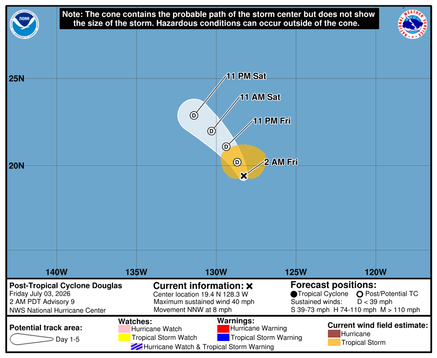
Official National Hurricane Center 5-day forecast cone and track for Post-Tropical Cyclone Douglas, final advisory.
Official NHC forecast cone and track (final advisory).NHC

Advisory timeline

  1. Advisory timeline #9

    Douglas becomes a post-tropical low. This is the final NHC advisory.

    Official NHC advisory text
    ZCZC MIATCPEP4 ALL
    TTAA00 KNHC DDHHMM
     
    BULLETIN
    Post-Tropical Cyclone Douglas Advisory Number   9
    NWS National Hurricane Center Miami FL       EP042026
    200 AM PDT Fri Jul 03 2026
     
    ...DOUGLAS BECOMES A POST-TROPICAL LOW...
    ...THIS IS THE FINAL NHC ADVISORY...
     
     
    SUMMARY OF 200 AM PDT...0900 UTC...INFORMATION
    ----------------------------------------------
    LOCATION...19.4N 128.3W
    ABOUT 1210 MI...1945 KM W OF THE SOUTHERN TIP OF BAJA CALIFORNIA
    MAXIMUM SUSTAINED WINDS...40 MPH...65 KM/H
    PRESENT MOVEMENT...NNW OR 335 DEGREES AT 8 MPH...13 KM/H
    MINIMUM CENTRAL PRESSURE...1003 MB...29.62 INCHES
     
     
    WATCHES AND WARNINGS
    --------------------
    There are no coastal watches or warnings in effect.
     
     
    DISCUSSION AND OUTLOOK
    ----------------------
    At 200 AM PDT (0900 UTC), the center of Post-Tropical Cyclone 
    Douglas was located near latitude 19.4 North, longitude 128.3 West. 
    The post-tropical cyclone is moving toward the north-northwest near 
    8 mph (13 km/h). A turn toward the northwest is expected later today 
    and on Saturday.
     
    Maximum sustained winds are near 40 mph (65 km/h) with higher gusts. 
    The post-tropical cyclone is expected to weaken over the next couple 
    of days and then dissipate by Sunday.
     
    Tropical-storm-force winds extend outward up to 125 miles (205 km) 
    to the north of the center.
     
    The estimated minimum central pressure is 1003 mb (29.62 inches).
     
     
    HAZARDS AFFECTING LAND
    ----------------------
    None.
     
     
    NEXT ADVISORY
    -------------
    This is the last public advisory issued by the National Hurricane 
    Center on this system. For additional information on this system 
    please see High Seas Forecasts issued by the National Weather 
    Service, under AWIPS header NFDHSFEPI, WMO header FZPN02 KWBC, and 
    on the web at ocean.weather.gov/shtml/NFDHSFEPI.php
    
     
    $$
    Forecaster Reinhart
     
    NNNN

    Source: NOAA / NHC

  2. Advisory timeline #8

    Douglas forecast to become a remnant low on Friday.

    Official NHC advisory text
    ZCZC MIATCPEP4 ALL
    TTAA00 KNHC DDHHMM
     
    BULLETIN
    Tropical Storm Douglas Advisory Number   8
    NWS National Hurricane Center Miami FL       EP042026
    800 PM PDT Thu Jul 02 2026
     
    ...DOUGLAS FORECAST TO BECOME A REMNANT LOW ON FRIDAY...
     
     
    SUMMARY OF 800 PM PDT...0300 UTC...INFORMATION
    ----------------------------------------------
    LOCATION...18.8N 127.6W
    ABOUT 1175 MI...1890 KM W OF THE SOUTHERN TIP OF BAJA CALIFORNIA
    MAXIMUM SUSTAINED WINDS...40 MPH...65 KM/H
    PRESENT MOVEMENT...NNW OR 345 DEGREES AT 7 MPH...11 KM/H
    MINIMUM CENTRAL PRESSURE...1003 MB...29.62 INCHES
     
     
    WATCHES AND WARNINGS
    --------------------
    There are no coastal watches or warnings in effect.
     
     
    DISCUSSION AND OUTLOOK
    ----------------------
    At 800 PM PDT (0300 UTC), the center of Tropical Storm Douglas was
    located near latitude 18.8 North, longitude 127.6 West. Douglas is
    moving toward the north-northwest near 7 mph (11 km/h), and this
    motion is expected to continue overnight. A motion toward the
    northwest is expected on Friday and Saturday.
     
    Maximum sustained winds remain near 40 mph (65 km/h) with higher 
    gusts. Douglas should begin to weaken overnight and is expected to 
    become a post-tropical cyclone on Friday.
     
    Tropical-storm-force winds extend outward up to 90 miles (150 km)
    from the center.
     
    The estimated minimum central pressure is 1003 mb (29.62 inches).
     
     
    HAZARDS AFFECTING LAND
    ----------------------
    None.
     
     
    NEXT ADVISORY
    -------------
    Next complete advisory at 200 AM PDT.
     
    $$
    Forecaster Blake
     
    NNNN

    Source: NOAA / NHC

  3. Advisory timeline #7

    Douglas now moving north-northwestward over the open Pacific. Expected to become a remnant low on Friday.

    Official NHC advisory text
    ZCZC MIATCPEP4 ALL
    TTAA00 KNHC DDHHMM
     
    BULLETIN
    Tropical Storm Douglas Advisory Number   7
    NWS National Hurricane Center Miami FL       EP042026
    200 PM PDT Thu Jul 02 2026
     
    ...DOUGLAS NOW MOVING NORTH-NORTHWESTWARD OVER THE OPEN PACIFIC...
    ...EXPECTED TO BECOME A REMNANT LOW ON FRIDAY...
     
     
    SUMMARY OF 200 PM PDT...2100 UTC...INFORMATION
    ----------------------------------------------
    LOCATION...18.0N 127.4W
    ABOUT 1180 MI...1900 KM WSW OF THE SOUTHERN TIP OF BAJA CALIFORNIA
    MAXIMUM SUSTAINED WINDS...40 MPH...65 KM/H
    PRESENT MOVEMENT...NNW OR 345 DEGREES AT 7 MPH...11 KM/H
    MINIMUM CENTRAL PRESSURE...1003 MB...29.62 INCHES
     
     
    WATCHES AND WARNINGS
    --------------------
    There are no coastal watches or warnings in effect.
     
     
    DISCUSSION AND OUTLOOK
    ----------------------
    At 200 PM PDT (2100 UTC), the center of Tropical Storm Douglas was
    located near latitude 18.0 North, longitude 127.4 West. Douglas is
    now moving toward the north-northwest near 7 mph (11 km/h), and this
    motion is expected to continue tonight. A motion toward the
    northwest is expected on Friday and Saturday.
     
    Maximum sustained winds are near 40 mph (65 km/h) with higher gusts.
    Little change in strength is expected for the next several hours. A
    weakening trend is forecast beginning late tonight, and Douglas is
    expected to become a post-tropical cyclone on Friday.
     
    Tropical-storm-force winds extend outward up to 90 miles (150 km)
    from the center.
     
    The estimated minimum central pressure is 1003 mb (29.62 inches).
     
     
    HAZARDS AFFECTING LAND
    ----------------------
    None.
     
     
    NEXT ADVISORY
    -------------
    Next complete advisory at 800 PM PDT.
     
    $$
    Forecaster Beven
     
    NNNN

    Source: NOAA / NHC

  4. Advisory timeline #6

    Douglas moving northward toward cooler water. Expected to become a remnant low on Friday.

    Official NHC advisory text
    ZCZC MIATCPEP4 ALL
    TTAA00 KNHC DDHHMM
     
    BULLETIN
    Tropical Storm Douglas Advisory Number   6
    NWS National Hurricane Center Miami FL       EP042026
    800 AM PDT Thu Jul 02 2026
     
    ...DOUGLAS MOVING NORTHWARD TOWARD COOLER WATER...
    ...EXPECTED TO BECOME A REMNANT LOW ON FRIDAY...
     
     
    SUMMARY OF 800 AM PDT...1500 UTC...INFORMATION
    ----------------------------------------------
    LOCATION...17.4N 127.1W
    ABOUT 1175 MI...1895 KM WSW OF THE SOUTHERN TIP OF BAJA CALIFORNIA
    MAXIMUM SUSTAINED WINDS...40 MPH...65 KM/H
    PRESENT MOVEMENT...N OR 355 DEGREES AT 6 MPH...9 KM/H
    MINIMUM CENTRAL PRESSURE...1003 MB...29.62 INCHES
     
     
    WATCHES AND WARNINGS
    --------------------
    There are no coastal watches or warnings in effect.
     
     
    DISCUSSION AND OUTLOOK
    ----------------------
    At 800 AM PDT (1500 UTC), the center of Tropical Storm Douglas was
    located near latitude 17.4 North, longitude 127.1 West. Douglas is
    moving toward the north near 6 mph (9 km/h)  and this motion is
    expected to continue today. A gradual turn to the northwest is
    forecast later tonight through the end of the week.
     
    Maximum sustained winds are near 40 mph (65 km/h) with higher gusts.
    Little change in strength is expected today. A weakening trend is 
    forecast beginning tonight into Friday, and Douglas is expected to 
    become a post-tropical cyclone on Friday.
    
    Tropical-storm-force winds extend outward up to 90 miles (150 km)
    from the center.
     
    The estimated minimum central pressure is 1003 mb (29.62 inches).
     
     
    HAZARDS AFFECTING LAND
    ----------------------
    None.
     
     
    NEXT ADVISORY
    -------------
    Next complete advisory at 200 PM PDT.
     
    $$
    Forecaster Beven
     
    NNNN

    Source: NOAA / NHC

  5. Advisory timeline #5

    Douglas moving northward. Expected to become a remnant low on Friday.

    Official NHC advisory text
    ZCZC MIATCPEP4 ALL
    TTAA00 KNHC DDHHMM
     
    BULLETIN
    Tropical Storm Douglas Advisory Number   5
    NWS National Hurricane Center Miami FL       EP042026
    200 AM PDT Thu Jul 02 2026
     
    ...DOUGLAS MOVING NORTHWARD...
    ...EXPECTED TO BECOME A REMNANT LOW ON FRIDAY...
     
     
    SUMMARY OF 200 AM PDT...0900 UTC...INFORMATION
    ----------------------------------------------
    LOCATION...17.0N 127.1W
    ABOUT 1185 MI...1910 KM WSW OF THE SOUTHERN TIP OF BAJA CALIFORNIA
    MAXIMUM SUSTAINED WINDS...40 MPH...65 KM/H
    PRESENT MOVEMENT...N OR 350 DEGREES AT 7 MPH...11 KM/H
    MINIMUM CENTRAL PRESSURE...1003 MB...29.62 INCHES
     
     
    WATCHES AND WARNINGS
    --------------------
    There are no coastal watches or warnings in effect.
     
     
    DISCUSSION AND OUTLOOK
    ----------------------
    At 200 AM PDT (0900 UTC), the center of Tropical Storm Douglas was
    located near latitude 17.0 North, longitude 127.1 West. Douglas is
    moving toward the north near 7 mph (11 km/h) and this motion is
    expected to continue today. A gradual turn to the northwest is
    forecast later tonight through the end of the week.
    
    Maximum sustained winds are near 40 mph (65 km/h) with higher gusts.
    Although some slight strengthening is possible the next several 
    hours, a weakening trend is forecast tonight into Friday. Douglas is 
    forecast to become a post-tropical cyclone on Friday.
     
    Tropical-storm-force winds extend outward up to 90 miles (150 km)
    from the center.
     
    The estimated minimum central pressure is 1003 mb (29.62 inches).
     
     
    HAZARDS AFFECTING LAND
    ----------------------
    None.
     
     
    NEXT ADVISORY
    -------------
    Next complete advisory at 800 AM PDT.
     
    $$
    Forecaster Kelly
     
    NNNN

    Source: NOAA / NHC