
Past storm
Post-Tropical Cyclone Genevieve
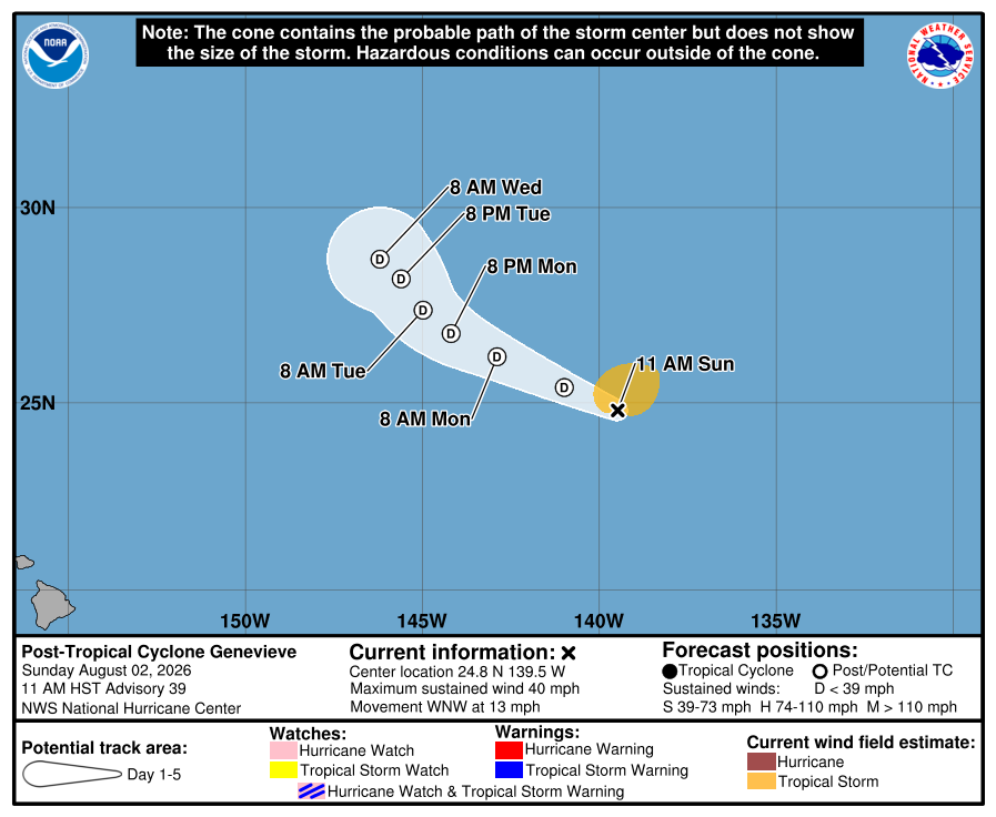
NHC issued its final advisory for Genevieve. The final official forecast graphic, interactive track, wind animation based on NOAA data, and recent official advisories are preserved below.
Highest classification reached: Category 5 HurricaneJul 24, 2026 – Aug 2, 2026
Genevieve advisory updated:
Key Facts
- Type
- Post-Tropical Cyclone
- Max sustained wind
- 40 mph
- Min pressure
- 1009 mb
- Movement
- WNW 13 mph
- Storm center to BCS
- 1527 mi
- Center to Mainland
- 1568 mi
- Type
- Post-Tropical Cyclone
- Max sustained wind
- 40 mph
- Min pressure
- 1009 mb
- Movement
- WNW 13 mph
- Storm center to BCS
- 1527 mi
- Center to Mainland
- 1568 mi
Track distance between reported center positions is estimated. Center distance does not show how far winds and rain can reach.
Historical Track
Map sources: NHC storm track and coneNOAA GFS wind. Visualization by BajaStorms.
Official Graphics
Advisory Timeline
Advisory
Genevieve becomes a post-tropical cyclone.
This is the last NHC advisory.
Official NHC advisory text
...GENEVIEVE BECOMES A POST-TROPICAL CYCLONE... ...THIS IS THE LAST NHC ADVISORY... As of 11:00 AM HST Sun Aug 02 the center of Genevieve was located near 24.8, -139.5 with movement WNW at 13 mph. The minimum central pressure was 1009 mb with maximum sustained winds of about 40 mph.
Source: NOAA / NHC
Advisory
Genevieve is forecast to become post-tropical later today.
Official NHC advisory text
...GENEVIEVE FORECAST TO BECOME POST-TROPICAL LATER TODAY... As of 5:00 AM HST Sun Aug 02 the center of Genevieve was located near 24.5, -138.4 with movement WNW at 14 mph. The minimum central pressure was 1006 mb with maximum sustained winds of about 45 mph.
Source: NOAA / NHC
Advisory
Genevieve is forecast to become post-tropical on Sunday.
Official NHC advisory text
...GENEVIEVE FORECAST TO BECOME POST-TROPICAL ON SUNDAY... As of 11:00 PM HST Sat Aug 01 the center of Genevieve was located near 23.9, -137.3 with movement WNW at 13 mph. The minimum central pressure was 1003 mb with maximum sustained winds of about 50 mph.
Source: NOAA / NHC
Advisory
Genevieve continues moving west-northwestward over open waters.
Official NHC advisory text
...GENEVIEVE CONTINUES MOVING WEST-NORTHWESTWARD OVER OPEN WATERS... As of 5:00 PM HST Sat Aug 01 the center of Genevieve was located near 23.5, -136.0 with movement WNW at 14 mph. The minimum central pressure was 1004 mb with maximum sustained winds of about 45 mph.
Source: NOAA / NHC
Advisory
Genevieve is forecast to gradually weaken.
Official NHC advisory text
...GENEVIEVE FORECAST TO GRADUALLY WEAKEN... As of 11:00 AM HST Sat Aug 01 the center of Genevieve was located near 23.3, -135.0 with movement WNW at 14 mph. The minimum central pressure was 1003 mb with maximum sustained winds of about 45 mph.
Source: NOAA / NHC